QUEENSLAND’S history-soaked Condamine River is a steadfast contributor to the mighty Murray-Darling river system. But a 700-kilometre long river has to start somewhere and in this wandering waterway’s headquarters on the slopes of the Great Divide you’ll find a swag of adventure outings, almost on Brisbane’s doorstep.
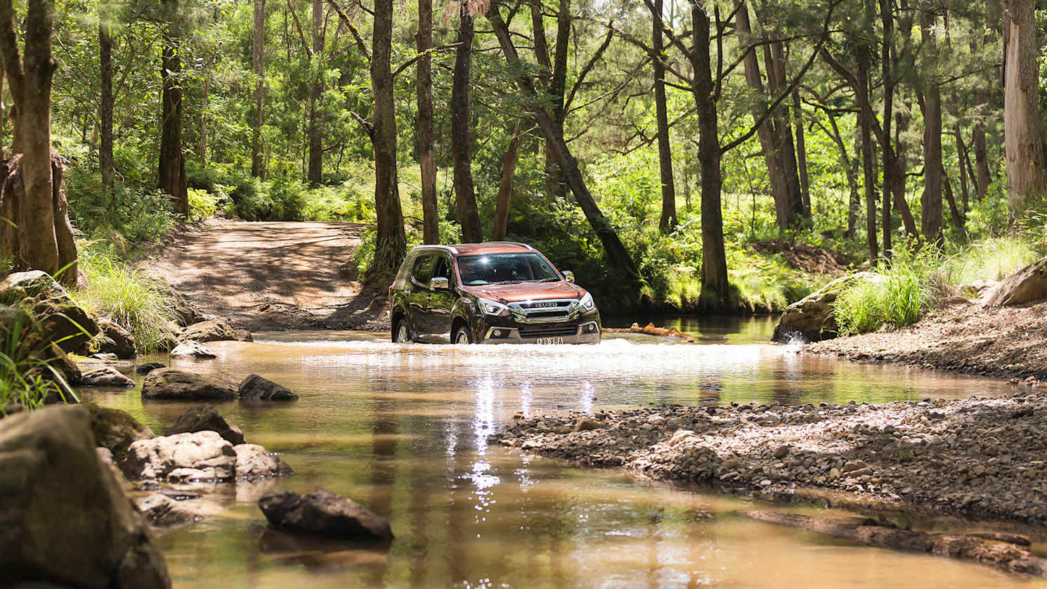
Among attractions for four-wheel drivers out this way is the Condamine River Gorge Road, a dirt and gravel road that crosses the river 14 times through pretty countryside. Big Smoke blues disappear right smart with the crunch of gravel, scent of gums and the chuckle of kookaburras along this back track between Boonah and Killarney.
.jpg)
Now this can be a medium to easy trek for the likes of a Toyota Prado or Isuzu’s MU-X but weather – we’re talking wet weather – can cause river levels to rise quickly, the road to get tricky and the track to be closed. In good condition the gorge road is also a great tour for four-wheel drive rookies; a place to check out low range and better understand your machine on dirt roads and through water crossings.
It needs a good weekend to make the most of this area around Main Range and Mount Superbus. There are spectacular waterfalls and green mountain scenes, there are campsites and caravan parks, there are the rustic charms of Killarney and Boonah townships and forever the clean and bright airs of country Australia.

Pack up and move on out.
As with many dirt-track expeditions, ground clearance is as important as traction on this Condamine River Road through Cambanoora Gorge. While this trek might look relatively easy four-wheeling when the road’s in good nick, there is often the question of clearing ruts and holes and always the business of crossing the river. Besides, there are campsites and lodgings through here accessible only by four-wheel drive, such as the rainforest cabins at Adjinbilly.

We’re starting out from Boonah, 90 kilometres from the centre of Brisbane; an easy run out toward Ipswich then down the Cunningham Highway before a left onto Highway 93. It’s a relaxed country tour on good bitumen. (From the Gold Coast it’s a 110 kilometres drive through Beaudesert and over on to Boonah.)
The tidy town of Boonah offers top spots for a late breakfast or picking up extra picnic supplies maybe. Make sure you’re fuelled up; it’s not a big distance but who knows what side adventures may pop up. Remember, mobile phone coverage in the gorge ranges between very limited and non-existent.
There are a couple of options heading toward Killarney from the east. Here we’re looking at a run that does a rough figure of eight between Boonah and Killarney to best experience the Great Dividing Range, the Condamine River Road and the river’s waterfalls. Don’t rely only on GPS and remember distances mentioned here could read up to 500 metres (or more) different on some odometers – some tourists spin their wheels more than others; some will get side-tracked with photo opportunities.
Day One
From Boonah to Killarney
.jpg)
Zero the wagon’s odometer opposite Boonah State School heading south on Rathdowney Road; be very careful on the fringe of town to get past the old Dugandan pub, one known to waylay travellers with cold beers and decent feeds.
About four kilometres out turn right toward Mount Alford and best from here to have headlights on low beam for these back-country roads.
Watch out for bounding native wildlife, head on through Mount Alford then turn left onto Dwyer Ridges Road before a T junction at 22km where we turn right on Carneys Creek Road and the mountains loom larger.
Head straight on to White Swamp at 29.5km – rather than turning right toward The Head Road and down Condamine River Road through to Killarney from here – for first let’s adventure up and over the hills alongside the rabbit fence; there’s also the business of that Head Road being steepish and narrow, best driven downhill on the way back.
.jpg)
Just past here we hit a narrow, winding gravel road. After a drop of rain this track, corrugated in parts, can become quite greasy and so high-range 4WD will be handy. (And be prepared, if the weather closes in these hills can become coolish, down to 15 degrees Celsius in the middle of a summer’s day.)
On past the rabbit fence and it’s over the border into the New South Wales shire of Tenterfield. Watch out for cattle, sometimes in the middle of the road, and a number of causeways through this historic area of White Swamp.
.jpg)
Around 50.5 kilometres, go right where the sign says Spring Creek, Queen Mary Falls and Killarney on the Head Gate Road; this is a tight and often chopped-up dirt road that runs over hills and dales through farming lands and Koreelah National Park. At 56 kilometres we’re back into Queensland before a left turn and another kilometre brings us to the eastern beginnings of the spectacular Cambanoora Gorge and the Condamine River Road.
The sign here reminds us this is a dry-weather road for high-clearance vehicles, reminds travellers to stay on the roadway and respect private property. It also recommends a speed of 30km/h for these next 20-odd kilometres; that’s quite sensible, for the two-way road is narrow with blind corners and no guide posts for citified folk.

Then there are the 14 river crossings which need care and, perhaps for some, low-range 4WD to steady a vehicle’s speed over rocky river bottoms. Most crossings can be okay in high range, it’s ground clearance that’s more the issue here. Most water depths can be gauged from the driver’s seat – send someone out to check if in doubt, especially after rain – and take the crossings steady to minimise damage to the environment and the vehicle.
The first crossing arrives at just over 63 kilometres out of Boonah on this suggested trek and from there it’s around 10 kilometres to the last of the river crossings before heading into Killarney township at 78 kilometres on our odo.
.jpg)
Along this meandering Condamine River Road – once a bullockys’ run – there are limited spots to pull over but there are picnic spots at the likes of Flaggie (sixth) and Rocky Crossing (seventh) where there’s a swimming hole too. And forever there is the magic of the gorge, its greenery and its wildlife.
And if looking to spend some extra time in the gorge for the sake of flora and fauna, check out Adjinbilly rainforest cabins about 12km before Killarney. Three self-contained, and self-sufficient, are nestled among the trees, close to cascading waters where platypus splash; there’s no mobile phones, no Internet or television. Bonus.
There are a swag of accommodation options in Killarney itself, such as the Killarney Hotel, the Killarney Sundown Motel and Tourist Park or Killarney View Cabins and Caravan Park.
Or you could head out of town, left up Spring Creek Road to Queen Mary Falls Caravan Park and Cabins, about 11km out, for the evening.
Day Two
From Killarney to Brisbane
.jpg)
Overnighting anywhere around Killarney allows for any number of side trips and some of the country’s best mountain scenery, including a number of waterfalls.
Opposite the Queen Mary Falls Caravan Park are two walking circuits – one short, one long – to catch these falls’ 40-metre plunge. From here Spring Creek Road runs another 14.5km before meeting up again with the Condamine River Road; along the way Spring Creek Café (open Thursday-Sunday) offers spectacular views over the gorge, as does the nearby Carr’s Lookout.
At the Spring Creek-River Road junction there are a couple of options, including the temptation of bearing left and heading back through the 14 river crossings to Killarney. Or a little over a kilometre up the road we could turn right back onto Head Gate Road and retrace yesterday’s route back to Boonah, 46km away.
.jpg)
The third option is to head straight on to Boonah down the Teviot Falls Road, past hill and glen while dodging mighty big and bully Hereford cattle.
Now this is two-way bitumen all the way, albeit always narrow bitumen, yet there is still adventure here as you head down a quite steep and very winding stretch of road edged by guard rails, grass trees and big gums. It is not suitable for trucks, buses, trailers or caravans (these should TURN AROUND says the sign) and be prepared to give way to uphill traffic.
Back onto the flats and back into more farming country, don’t get over-excited about the more open road because there are floodways and a couple of big lumps in the road. Keep an eye out for trundling tractors.

At 18km from the Spring Creek-River Road junction turn left back toward Boonah, follow the signs and another 14km from here should bring you back onto the Boonah-Rathdowney Road. Or at Croftby you could turn left to Lake Moogerah, then back onto the Cunningham Highway near Aratula for a 90km run to Brisbane.
Again, when cutting across country around here, don’t over-rely on satellite navigation systems. Shell out for a Hema Road Atlas, let everyone get a better idea of where the adventure is going and soak in the real, not the virtual, countryside.

Us? We’d be heading back through Boonah for another top coffee and feed at Café 17 (17 High Street) to take one more breather before heading back to the Big Smoke.
Note: Always travel in a group if possible. Always take vehicle-recovery equipment. Our track and trail ratings apply to travel during dry weather only; track conditions will change in wet weather.


.jpg)
.jpg)
.jpg)


